
PlantCV Geospatial
Open-source tools for measuring plants from drone and aerial imagery.
From field imagery to plot-level data
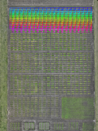
PlantCV Geospatial is an add-on package to PlantCV that applies the same modular, open-source approach to geospatial imagery. It reads georeferenced images such as orthomosaics and elevation models, defines plots across a field, and extracts traits for every plot.
Because its functions are modular, it can be adapted to different plot designs and imaging systems instead of being locked into a single platform or pipeline.
Get Started
PlantCV Geospatial is a Python package that you can install from PyPI or from source. First, install PlantCV. Then install PlantCV Geospatial.
Learn by example
Follow our step-by-step tutorial to calculate plant height from geospatial images, from loading your data to exporting results.
Tutorial Gallery (see the Geospatial section)
See how others are using PlantCV in our Publications
Open source and community driven
PlantCV Geospatial is free to use under the Mozilla Public License 2.0. We welcome questions, bug reports, and contributions.
Ask a question or report an issue on GitHub Issues
Read the Contribution Guide
FAQs
What is PlantCV Geospatial?
1
PlantCV Geospatial is an open-source Python package as an add-on to PlantCV for analyzing drone, satellite, and other aerial imagery of field experiments. PlantCV-geospatial builds on the existing functions in PlantCV to enable researchers in academia and industry to analyze data quickly, effectively, and at low cost. The software is maintained by the same PlantCV development team to ensure longevity and sustainability of the project.
How does PlantCV Geospatial compare to other software?
2
Drone imaging workflows usually have two steps:
Building the orthomosaic from raw drone images, using photogrammetry software such as Agisoft Metashape, Pix4D, or OpenDroneMap.
Extracting plot-level data from that orthomosaic.
PlantCV Geospatial handles step 2. Compared with commercial platforms, it's free, open source, and fully scriptable, so your analyses are transparent and reproducible. Compared with other open-source tools, such as FIELDImageR (an R package), PlantCV Geospatial is written in Python and connects directly to the wider PlantCV ecosystem. That lets you use the same tools and data formats for greenhouse, lab, and field imaging.
What data types are supported?
3
GeoTIFF and NetCDF images, and GeoJSON for plot boundaries, points, and polygons. Any image types accepted by PlantCV, such as TIFF, JPEG, PNG, etc. are all supported by PlantCV-Geospatial, but GeoTIFF and NetCDF images have the additional coordinate data useful for analyzing geospatial images.
What cameras or drones does it work with?
4
PlantCV Geospatial isn't tied to any specific drone, camera, or manufacturer. It works with any georeferenced image saved as a GeoTIFF or NetCDF file, such as orthomosaics and elevation models created in photogrammetry software like Agisoft Metashape, Pix4D, or OpenDroneMap. This includes imagery from RGB and multispectral sensors. Images from crewed aircraft or ground-based platforms also work. Non-georeferenced images (such as JPG, TIFF, etc.) are supported, although those data types may not support all of the tools if they lack georeferencing.
Is PlantCV Geospatial free to use?
5
Yes. PlantCV Geospatial is free and open source under the Mozilla Public License 2.0. Academic, government, nonprofit, and commercial users can all use it at no cost, including in proprietary workflows. See details on the Mozilla license for what reuse is permitted.
How do I cite PlantCV Geospatial?
6
Please see the citation page. Users should cite both PlantCV and PlantCV Geospatial in publications.